


PUNTA DE MANABIQUE WILDLIFE REFUGE

Data Sheet
- Name of protected area: Wildlife Refuge.
- Manager Entity: National Protected Areas Council (CONAP for its initials in Spanish).
- Location: Municipality of Puerto Barrios, Izabal, geographic coordinates 15° 50' North latitude and 88°28' West Longitude
- Location and/or address of headquarters' area: CONAP's Headquarters in Guatemala and CONAP's offices at Puerto Barrios
- Area: 151,878 hectares (1,519 Km2): 49,289 hectares of land area and 102,589 hectares of marine zone including internal waters
- Date of declaration: 2005, Congress Decree No. 23-2005
Characteristic
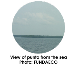
Punta de Manabique Wildlife Refuge (Punta de Manabique WR) is located at Izabal, Puerto Barrios. The refuge is the first marine-coastal protected area within the SIGAP (Guatemalan Protected Areas System). The main natural attributes that the area has are reef zones, sea grass, fresh and brackish water, remnants of broadleaf forests including mangrove. The area has an important dynamic as a transition zone between the continental shelf and high seas; also it owns a wealth in diverse species, which include those liked to reefs which have the characteristic of being resilient in a very changing environment. The Refuge offers significant opportunities for recreation and tourism for its uniqueness in scenic beauty.
According to the Hold bridge models the area lies within the life zone of Humid Subtropical Forest (warm), [bmh S (c)], (CECON-CDC, 1992). The particularity of the area is due to its configuration, geographical position, orographic relationships, substrate's nature and very high groundwater level. Therefore ecosystems have been established with different characteristics than the other low-lying areas of Guatemala with species of flora and fauna highly adapted to these conditions.
Hydrology is very complex issue in Punta de Manabique WR due to the area characteristics and for containing the lowest and final part of the Motagua River. It is directly affected by the dynamics in the upper part of the basin, from the sites of greatest susceptibility to erosion of Guatemala such as El Quiché. The Motagua River has the higher flow rate in the area, with an average flow rate of 530 m3/s although it is confined to the eastern boundary it has a great effect on its mouth on the Gulf coast of Honduras. In addition, during the past and current centuries the material that carries the Motagua River is formed by waste and sewage collected along its route, especially in the capital city of Guatemala and agricultural areas of the Motagua Valley.
The most important rivers of Punta de Manabique WR are: Motagua Viejo, San Francisco and Piteros which discharge into the Gulf of Honduras; the Machacas in the western sector discharge into the Amatique Bay. There are small streams from one to five kms. in length such as Chiquito River (tributary of the Motagua), Estero Motagüilla, Estereo Guineo, San Francisco del Mar (discharged along with the Piteros and San Francisco Rivers), Creek Grande (discharged into the English Channel) and Pioquinto rivers and Creek Negro which run through the western marshy area to the south of Machacas.
Two thirds of the area (67%) corresponds to marine environments both the Gulf of Honduras as Amatique and La Graciosa Bays. Three areas define the marine coastal wetland characteristics: Amatique Bay, Gulf of Honduras and the inlands marshes. Greater flow rates of the country are discharged into the Bay via Rio Dulce which transforms it into an estuarine lagoon. This Bay catches huge amounts of sediments, has abundant sea grass, particularly of Thalassia, and has high productivity and aquatic biodiversity.
Flora
The wetland forest cover, of Punta de Manabique, is a characteristic of a subtropical floodable forest. For the area is reported a total of 453 flora species distributed in 103 families mainly the following: Fabaceae (6.4%), Melastomaceae (5.3%), Mimosaceae (4.4%) and Verbenaceae (4.4%).
The marine ecosystem is dominated by shallow water, low salinity and lower temperature to the Gulf due to the contribution of freshwaters by the continental shelf streams. On the sandy bottom there are two or three reef formations. Its main flora is constituted by various sea grasses and has reported for the area a total of 4 species predominating Thalassia gender (Arrvillaga 2000, Galan 2006). Plankton the organisms that live on the bottom and fish are the most abundant and special fauna. It houses populations of fish and crustaceans in juvenile stages which has an important protective function.
Tropical forests subject to flooding represent more than 50% of the land section. They are dominated by the palm (Manicaria saccifera) and accompanied by species such as palo sangre or Cahué (Pterocarpus officinalis), barillo (Symphonia globulifera), sapote bobo (Pachira aquatica) and Santa Maria (Calophyllum brasiliense var rekoi). The confra and barillo have a restricted distribution to the wetland and other wetlands of the northern coast of Guatemala. The marshes have a height up to 30 meters, remain waterlogged at least nine months and dry from March to May, they are freshwaters.
Fauna
Crustaceans and mollusks: Species of crustaceans of the families of shrimps, crabs, hermit crabs, and sand crabs have been determined, various families of mollusks were found, and the snails of the Neritidae family are the most abundant in Graciosa Bay. .
Fishes: At El Refugio have been registered 54 families of fishes mostly with one representative, Carangidae and Haemulidae families. It is important to mention that this area is a place of growth of fish and crustaceans which are developed in the red mangrove roots (Rizophora mangle).
Herpetofauna: At El Refugio 11 species of amphibians and 32 reptiles (especially crocodiles and green iguanas), and at the Reserve may be noted abundant species of frogs, corytophanes, lizards, snakes, sand turtles, and iguanas.
Birds: Studies have registered 323 species classified in 59 families, is remarkable the high presence of Neartic migratory birds, 118 species represent 29% of shorebirds and seabirds. Among the species most closely observed are: pajuil, guandololas, hummingbirds and others.
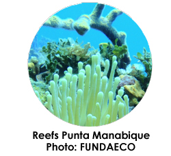
Corals: The Punta de Manabique Wildlife Refuge has a total of 40 species reported belonging to 5 orders distributed in approximately 18 families (Annex 2). The main order is the Escleractina with 28 species and main families Faviidae (8 species), Mussidae (5 sps), Agariciidae (4 sps) and Plexauridae (5 sps).


